Why is the River Thames so famous?
Two thousand years of trade and power on one river, three World Heritage sites on its banks, the sewer that saved it and the wildlife that came back: the real reasons the Thames is famous.
 By James Whitfield, London river and travel writer
Booking Choice
The fame is the addresses: Parliament, the Tower, Greenwich and the rest were built facing this water, and the river is the one angle that shows all of them in a line.
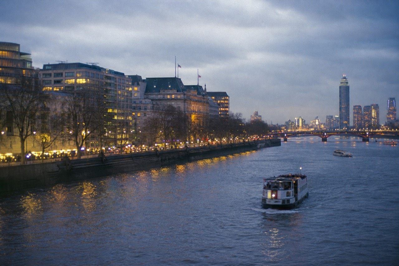
The Thames is not big. At around 215 miles it is shorter than the Severn, it carries a fraction of the water of the Rhine, and a stranger flown over it without context would see an ordinary brown European river. Its fame has nothing to do with the geography and everything to do with what got built on the banks, starting with a bridge the Romans put across it in the first century and continuing to the flood barrier that now stands between London and the North Sea.
That is the honest frame for the question. This river is famous the way a street can be famous: because of the addresses on it. Below is what those addresses are, in the order history put them there, with the figures that hold each claim up.
Why is the River Thames so famous?
Because London was built on it and grew rich from it. The Romans founded Londinium beside it around AD 47 to 50 for the bridging point and the sea access, the Port of London made it one of the world's great trading rivers, and three UNESCO World Heritage sites now sit on its banks in a single city. No other river carries that concentration.
Start with the founding decision, because everything follows from it. The Romans did not settle a pre-existing native town. They chose a spot on the north bank with small hills that gave dry, flood-free ground, a channel narrow enough to bridge across to Southwark, and a tidal reach that let ships sail up from the North Sea without transferring cargo. The London Museum's timeline of Roman London sets out that reasoning, and it is the whole city's foundation logic in one sentence: bridge here, dock here, build here.
The second layer is the port. By the eighteenth and nineteenth centuries the Pool of London, the reach immediately below London Bridge, was the beating middle of a global trading system. Overseas trade through the port grew from 1,682 ships and 234,639 tons in 1751 to 3,663 ships and 620,845 tons by 1794, while coastal traffic nearly doubled over the same decades to almost 12,000 vessels a year. Wharves lined miles of both banks, and the ships moored so densely that contemporary images look like a floating forest.
The third layer is the one visitors actually meet. Because the money and the power sat on the water, so did the buildings: Parliament, the Tower, the Abbey, the naval college at Greenwich, the wharves that became galleries and the docks that became Canary Wharf. Fame in this case is an accumulation, not an event.
What is actually on the banks of the Thames?
Three UNESCO World Heritage sites within a dozen miles of each other: the Palace of Westminster with Westminster Abbey, inscribed in 1987; the Tower of London, inscribed in 1988; and Maritime Greenwich, inscribed in 1997. Add St Paul's, Tower Bridge, the South Bank and Canary Wharf and you have most of London's postcard in one line.
The density is the point. Plenty of rivers have a famous building on them. This one has a royal palace turned parliament, an eleventh-century fortress, a baroque naval hospital and a cathedral dome inside a stretch you can travel in an hour by boat, plus the twentieth and twenty-first century additions that were deliberately put on the water to join the sequence.
| Landmark | Bank | Why it is there |
|---|---|---|
| Palace of Westminster and Westminster Abbey | North | Royal and parliamentary centre since the eleventh century; World Heritage site from 1987 |
| London Eye and the South Bank complex | South | Twentieth-century cultural quarter built facing the government bank |
| Somerset House | North | Georgian public offices with a river frontage built to be seen from the water |
| St Paul's Cathedral | North | Rebuilt after 1666 on the ridge above the Pool of London |
| Shakespeare's Globe and Tate Modern | South | The old entertainment and industrial bank, outside the medieval City's control |
| Tower of London | North | Norman fortress guarding the river approach; World Heritage site from 1988 |
| Tower Bridge | Both | Built in the 1890s to cross downstream of London Bridge without blocking shipping |
| Canary Wharf | North, Isle of Dogs | The West India Docks, redeveloped after the port moved downstream |
| Cutty Sark, Old Royal Naval College, Royal Observatory | South | Maritime Greenwich, the navy's ceremonial and scientific centre; World Heritage site from 1997 |
| Thames Barrier | Both | London's tidal flood defence, operational since 1982 |
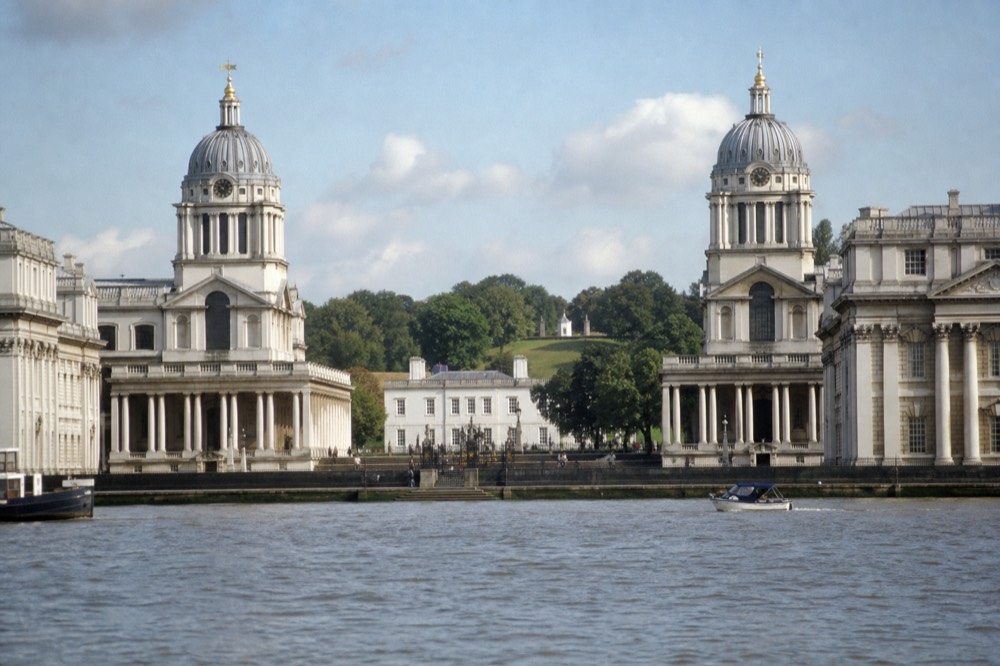
The Greenwich end deserves its own note, because it is the one composition on the river designed to be seen from mid-stream. The Queen's House framed between the two colonnaded blocks with the Observatory on the hill behind only resolves properly from the water, which is why arriving by boat gives you the view the architects drew. The Maritime Greenwich inscription covers the site as a single ensemble rather than a set of separate buildings, and that is how it reads from a deck.
Seeing the whole sequence in one day is a solved problem, because the piers sit at the landmarks. A 24-hour pass covering Westminster, the London Eye, the Tower and Greenwich lets you get off at three of them and pick the next boat up, which is a different proposition from a single sailing that carries you past everything without stopping. The river pass in detail sets out the timetable and where it pays off.
How did the Thames become famous for being filthy?
Through the Great Stink of 1858, when a hot summer turned the river beside Parliament into a public emergency. The response was Joseph Bazalgette's intercepting sewer system: about 82 miles of main sewers and 1,100 miles of street sewers, begun in 1859 at a cost of roughly £4.2 million, which carried London's waste downstream instead of into the middle of the city.
The Great Stink is the moment the river's reputation flipped. Through June, July and August 1858 the heat concentrated the sewage that London had been discharging into the water, the smell reached the Houses of Parliament, and legislation that had stalled for years passed in weeks. Nothing motivates a legislature like a bad smell in its own building. The river's darker ledger from the same era, what the Victorians recorded recovering from the water, reads like the companion piece to the clean-up story.
What Bazalgette built for the Metropolitan Board of Works is still the spine of London's drainage. Main intercepting sewers running roughly 82 miles, over a thousand miles of street sewers feeding them, and pumping stations at Crossness, Deptford, Abbey Mills and Chelsea to lift the flow eastward. Construction started in 1859 and the system was substantially complete between 1865 and 1875, alongside the embankments that narrowed the river and gave central London its riverside roads.
The design had one weakness that took 150 years to fix. It was a combined system, carrying rainwater and sewage in the same pipes, sized for a city of a few million. When it fills, it overflows into the river by design rather than by failure, which is why the modern Tideway tunnel was built underneath it: 25 kilometres of storage and interception under the river through London, which has captured more than 20 million tonnes of sewage since it began taking connections in August 2024. Storm-overflow spills across the network fell from 23,061 in 2024 to 9,186 in 2025. The water-quality story in full, including where you may and may not get into it, is in whether you can swim in the Thames.
| Period | What the river was known for |
|---|---|
| AD 47 to 50 | The Roman bridging point and sea access that founded Londinium |
| Medieval to Tudor | London Bridge, the wharves, the royal palaces strung along the bank |
| 17th to early 19th century | Frost fairs on the ice, the last major one in February 1814 |
| 1751 to 1794 | The Pool of London: overseas shipping more than doubling in tonnage |
| Summer 1858 | The Great Stink, and the sewer programme it forced |
| 1859 to 1875 | Bazalgette's intercepting sewers and the embankments |
| 1982 | The Thames Barrier becomes operational |
| 1989 | The Marchioness disaster, and the safety regime that followed |
| 2002 | Lifeboat stations established on the tidal river through London |
| 2024 to 2026 | The Tideway tunnel comes into full use and spill numbers fall sharply |
What came back to the river, and how do we know?
Seals, seahorses, eels and small sharks. The estuary count stands at 431 harbour seals and 714 grey seals hauled out on the sandbanks. Short-snouted seahorses have been recorded as far upstream as Battersea, and the shark species present include tope, starry smoothhound and spurdog.
The Zoological Society of London published the second edition of its State of the Thames assessment in January 2026, tracking 21 indicators across the tidal river. The headline findings were long-term increases in a range of wading bird species, short-term increases in marine mammals, and the restoration of intertidal habitat that works as a nursery for fish. The State of the Thames project is the nearest thing the river has to an annual check-up, and it is the source most of the cheerful headlines are drawn from.
The report is careful in ways the headlines are not, and repeating it honestly matters more than repeating it enthusiastically. The number of fish species recorded in tidal areas has slipped slightly since the early 1990s, nitrate concentrations from treated effluent are rising gradually, and warming water is listed among the pressures. Recovery and pressure are running at the same time.
| Indicator | Where it stands |
|---|---|
| Harbour seals, Greater Thames Estuary | 431 counted on the sandbanks |
| Grey seals, Greater Thames Estuary | 714 counted on the sandbanks |
| Short-snouted seahorses | Recorded as far upstream as Battersea |
| Sharks present in the tidal river and estuary | Tope, starry smoothhound, spurdog |
| Wading birds | Long-term increases across a range of species |
| Fish species in tidal areas | Slight decline since the early 1990s |
| Sewage intercepted by the Tideway tunnel | More than 20 million tonnes since August 2024 |
| Storm-overflow spills, network-wide | 9,186 in 2025, down from 23,061 in 2024 |
Why does London need the Thames Barrier?
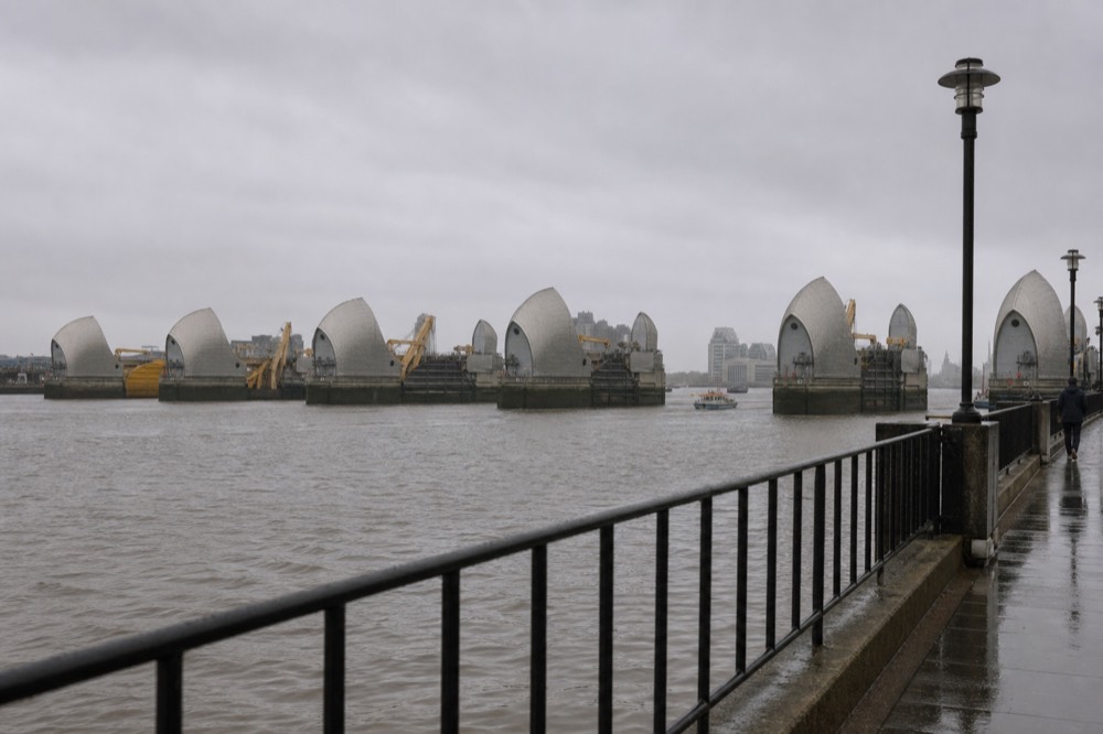
Because the tidal Thames can push a North Sea surge straight into the city. The Barrier became operational in 1982, cost roughly £535 million, is run by the Environment Agency, and closed 211 times between 1982 and 2025. Estuary sea level has been rising at about 4.1 millimetres a year since 1993.
The threat is not river flooding from rain upstream, which is what most people picture. It is a storm surge coming the other way, funnelled up a narrowing estuary and meeting a high tide, which is what nearly drowned east London in 1953. The Barrier's ten steel gates rotate up from the riverbed to close the channel and hold that surge out.
Two hundred and eleven closures in forty-three years works out at roughly five a year on average, but the distribution is what alarms engineers rather than the total: closures cluster in wet winters, and the long-term rate has risen. The estuary sea level figure of about 4.1 millimetres a year over 1993 to 2024 is faster than several earlier assessments assumed, which is why the defence programme is reviewed rather than declared finished.
There is a nice symmetry in the Barrier being the river's newest famous structure. It sits at Woolwich, roughly where the Thames Path national trail leaves London, and it is the eastern turning point for the fast boats that run down from the centre. Seeing it from the water is the only way to understand the scale of the piers, which look modest from the bank and enormous from beside them.
Is the Thames the longest river in England?
Yes, at around 215 miles or 346 kilometres, the longest river lying entirely within England. The Severn is longer overall at about 220 miles, but it rises in Wales, so the two claims do not conflict. The Thames source itself is disputed, which is part of the fun.
The conventional source is Thames Head, a field near Kemble in Gloucestershire that is dry for much of the summer. The rival claim is Seven Springs, the source of the River Churn, which joins the Thames near Cricklade and would add roughly fourteen miles to the total. Measured that way the river runs about 229 miles and overtakes the Severn, which is why the argument has never entirely died. No single legally designated source settles it.
The river changes character twice along that length. From the source down to Teddington Lock it is a non-tidal river managed by the Environment Agency, around 147 miles of it, with locks, weirs and the market towns most people picture when they think of the upper Thames. Below Teddington it becomes tidal, and responsibility passes to the Port of London Authority, whose remit covers roughly 95 miles from Teddington out to the North Sea.
Walking the whole thing is a recognised undertaking. The Thames Path national trail runs 185.2 miles from the source to the Woolwich Foot Tunnel, typically completed in about fourteen days, and it joins the England Coast Path at Woolwich to make a continuous source-to-sea route of about 232 miles. The full set of geographic figures is collected in five facts about the Thames.
Why does every visitor end up on the river or beside it?
Because London's best buildings face the water and its streets turn away from it. The river frontage is the one uncluttered angle in the city, and a boat is the only way to travel it. A 24-hour hop-on hop-off pass covering four central piers costs £24.95, and the one-way run from Westminster to Greenwich starts at £17.20.
The practical case is stronger than the sentimental one. Central London is dense, its skyline is broken by everything in front of it, and the composed views the buildings were designed for are almost all river views. Somerset House, Greenwich, the Palace of Westminster and the Tower were all built to be approached or seen from the water, and the pavement versions are consolation prizes.
Use is rising, and not only among tourists. London river services carried a record of roughly 10.5 million journey stages in 2024/25, up about 9 per cent year on year, according to Transport for London's Travel in London analysis. Interestingly the tour and charter share of that fell about 8 per cent over the same period, which suggests the growth is Londoners using boats to get places rather than visitors using them to look at things.
For a first visit the choice is mostly between coverage and time. A day pass lets you break the journey at the Tower and Greenwich and come back when you like, which suits a whole day; the one-way hour to Greenwich suits a half day; a 40-minute circular from the London Eye at £15.50 suits an afternoon with an hour to spare. Every option is compared, priced and ranked on Thames River Cruises, and the full head-to-head lives in the best cruise comparison. If a full day on the water is the plan, check what the day pass costs on your date before you commit to single tickets.
The short circular is the low-commitment version, and it covers the most photographed two miles in Britain. Forty minutes from the foot of the wheel takes in Parliament, the South Bank and the bridges, and you can see the live times for the circular sailing if the schedule is tight. The London Eye river cruise guide sets out where it goes and what it skips.
If the aim is the lit version rather than the daylight one, the evening sailings from Tower Pier put the famous buildings against a dark sky for two hours from £35, which the night cruise guide covers in detail. And if the whole question is whether any of it is worth the money, that argument is settled with prices and ratings in is a Thames cruise worth it.
Common questions
What is the River Thames most famous for?
Being the river London was built on. The Romans founded Londinium beside it around AD 47 to 50 for its bridging point and sea access, the Port of London made it one of the world's great trading rivers, and three UNESCO World Heritage sites sit on its banks: Westminster, the Tower of London and Maritime Greenwich. The Great Stink of 1858 and the sewer system that followed made it famous a second time.How old is the River Thames as a route into London?
The city's use of it dates to the Roman foundation around AD 47 to 50, when the site was chosen partly because ships could sail up from the North Sea and partly because the channel was narrow enough to bridge. The river itself is far older, and prehistoric human remains and Bronze Age metalwork recovered from it show it mattered long before the Romans arrived.Why was the Thames so polluted?
London discharged its waste straight into the water while its population grew far beyond what the drainage could handle. The Great Stink of summer 1858 forced action, and Joseph Bazalgette built about 82 miles of intercepting sewers and 1,100 miles of street sewers from 1859. That system was combined, carrying rain and sewage together, so it overflowed in heavy weather until the Tideway tunnel was added underneath it.How many times has the Thames Barrier closed?
211 times between becoming operational in 1982 and 2025. It is run by the Environment Agency and cost roughly £535 million to build. Closures cluster in wet winters rather than spreading evenly, and estuary sea level rising at about 4.1 millimetres a year since 1993 is the reason London's tidal defences are under continuous review.What is the best way to see the famous stretch of the Thames?
By boat, between Westminster and Greenwich, which covers Parliament, the South Bank, St Paul's, the Tower, Tower Bridge and the maritime buildings at the far end. A one-way sailing takes about an hour from £17.20, a 24-hour pass covering four piers costs £24.95, and the fast boats run further east to the Thames Barrier.So the fame is earned, but not by the water. Take the river out of London and you remove the reason the city exists, the port that paid for it, the emergency that gave it modern drains and the defence that keeps the sea out of it. Everything famous about the Thames is really something famous about London, told from the one angle where you can see all of it at once.
Choose Your Thames Cruise
Start Here: An Option For This Trip
Have a travel date in mind? Choose your date to your hour on the landmark run before arranging the rest of your day.
1 hour one-way from Westminster Pier to Greenwich past St Paul's, the Tower and Tower Bridge, live English commentary, from £17.20, rated 4.5 across 25,220 GetYourGuide reviews, free cancellation on most dates.
Check Dates For Westminster to Greenwich Sightseeing CruiseNo verified cruise on this site matches those choices. Adjust them, or reset for the editorial recommendation.
Compare Options, Match Your Day And Estimate Costs
- Westminster to Greenwich Sightseeing Cruise: 1 hour one-way from Westminster Pier to Greenwich past St Paul's, the Tower and Tower Bridge, live English commentary, from £17.20, rated 4.5 across 25,220 GetYourGuide reviews, free cancellation on most dates.
- River Thames Hop-On Hop-Off Cruise, 24-Hour Pass: 24-hour pass between Westminster, London Eye, Tower and Greenwich piers, hop as often as you like, live commentary, from £24.95, rated 4.4 across 3,283 GetYourGuide reviews, free cancellation on most dates.
- 70-Minute RIB Voyage to the Thames Barrier: 70-minute high-speed RIB from Embankment Pier to the Thames Barrier and back, the full length of the tidal river, from £75.48, rated 4.9 across 803 Viator reviews, free cancellation on most dates.
- Tower Bridge Circular Cruise from Westminster: 1-hour circular from Westminster Pier to St Katharine's and back, turning under Tower Bridge, from £14, rated 4.2 across 523 Viator reviews, free cancellation on most dates.
- London Eye River Cruise: 40-minute circular from London Eye Pier, Big Ben and the South Bank waterfront, live guide, from £15.50, rated 4.8 across 1,912 Viator reviews, free cancellation on most dates.
- Evening Cruise with Bubbly and Canapés: 2-hour evening cruise from Tower Millennium Pier, glass of sparkling wine, canapés and live music as the bridges light up, from £35, rated 4.4 across 2,787 GetYourGuide reviews, free cancellation on most dates.
Compare Your Whole-Party Costs
Enter what you would pay in the same currency for the cruise and for your alternative, including transport and meals for each.